


Medicine Precinct, Lincoln County, Nebraska
About
Outline

Summary
| Unique Area Identifier | 613574 |
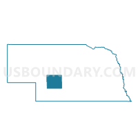
| Name | Medicine Precinct |
| County | Lincoln County |
| State | Nebraska |
| Area (square miles) | 192.48 |
| Land Area (square miles) | 192.21 |
| Water Area (square miles) | 0.27 |
| % of Land Area | 99.86 |
| % of Water Area | 0.14 |
| Latitude of the Internal Point | 40.79633610 |
| Longtitude of the Internal Point | -100.72565930 |
Maps

Graphs
Select a template below for downloading or customizing gragh for Medicine Precinct, Lincoln County, Nebraska


Neighbors
Neighoring Voting District (by Name) Neighboring Voting District on the Map
- District 1 Precinct, Hayes County, NE
- Maxwell Precinct, Lincoln County, NE
- Maywood Precinct, Frontier County, NE
- Osgood Precinct, Lincoln County, NE
- Sellers Precinct, Lincoln County, NE
- Wallace Precinct, Lincoln County, NE
Top 10 Neighboring County Subdivision (by Population) Neighboring County Subdivision on the Map
- Osgood precinct, Lincoln County, NE (1,950)
- Sellers precinct, Lincoln County, NE (968)
- Maxwell precinct, Lincoln County, NE (741)
- Wallace precinct, Lincoln County, NE (668)
- East Laird precinct, Frontier County, NE (353)
- Medicine precinct, Lincoln County, NE (322)
- Concord precinct, Hayes County, NE (28)
- Valley precinct, Hayes County, NE (26)
- West Laird precinct, Frontier County, NE (23)
Top 10 Neighboring Place (by Population) Neighboring Place on the Map
Top 10 Neighboring Unified School District (by Population) Neighboring Unified School District on the Map
- North Platte Public Schools, NE (28,794)
- Medicine Valley Public Schools, NE (1,356)
- Maxwell Public Schools, NE (964)
- Maywood Public Schools, NE (871)
- Wallace Public School District 65 R, NE (803)
- Hayes Center Public Schools, NE (677)
Top 10 Neighboring State Legislative District Upper Chamber (by Population) Neighboring State Legislative District Upper Chamber on the Map
Top 10 Neighboring 111th Congressional District (by Population) Neighboring 111th Congressional District on the Map
Top 10 Neighboring Census Tract (by Population) Neighboring Census Tract on the Map
- Census Tract 9606, Lincoln County, NE (3,861)
- Census Tract 9597, Lincoln County, NE (3,669)
- Census Tract 9611, Frontier County, NE (2,756)
- Census Tract 9615, Hayes County, NE (967)
Top 10 Neighboring 5-Digit ZIP Code Tabulation Area (by Population) Neighboring 5-Digit ZIP Code Tabulation Area on the Map
- 69101, NE (29,904)
- 69025, NE (1,220)
- 69151, NE (815)
- 69032, NE (498)
- 69038, NE (449)
- 69170, NE (372)
- 69132, NE (117)